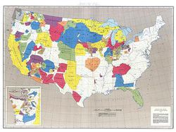
Large, colorful map that shows the results of cases before the U.S. Indian Claims Commission or U.S. Court of Claims in which an American Indian tribe proved it’s original tribal occupancy of a tract within the continental United States.
The map contains an inset which provides additional details of the Pacific Northwest region. The information displayed in this map was prepared under the direction of the Indian Claims Commission as part of its final report. This Native American Judicial Lands map was compiled, edited, and published by the U.S. Geological Survey in 1978.
Native American Judicial Lands Map is 51" x 38", which makes it a great poster for displaying in classrooms, libraries and schools.